Today, @UNISFA_1 military observers carried out routine vehicle and foot patrols across villages in southern #Abyei. UNISFA peacekeepers are on high alert as they ensure peace and security in #Abyei. pic.twitter.com/ck6TJTWBXM
— UNISFA (@UNISFA_1) December 7, 2023
________________________________
Related
Map showing oil rich Abyei Area on the border of Sudan and South Sudan:
The Abyei Area (Arabic: منطقة أبيي) is an area of 10,546 km2 or 4,072 sq mi[2] on the border between South Sudan and Sudan that has been accorded "special administrative status" by the 2004 Protocol on the Resolution of the Abyei Conflict (Abyei Protocol) in the Comprehensive Peace Agreement (CPA) that ended the Second Sudanese Civil War.[3] The capital of the Abyei Area is Abyei Town. Under the terms of the Abyei Protocol, the Abyei Area is considered, on an interim basis, to be simultaneously part of both the Republic of South Sudan and Republic of Sudan, effectively a condominium. -Wikipedia
_____________
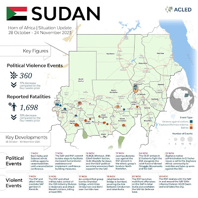
THIS ACLED map shows Abyei near E. Darfur and W. Kordofan in Sudan:
To view a larger map visit the original report and click on
_____________
Sudan
ACLED update on Sudan situation 28 Oct - 24 Nov 2023
'Unravelling the conflict dynamics in Darfur'
_____________
South Sudan
UN OCHA latest report on South Sudan
'Severity of humanitarian conditions and number of people in need'
_____________
Abyei Area on the border of Sudan and South Sudan
ACLED analysis on Abyei Area March 2023
'Deadly violence in the disputed Abyei Area'
END


No comments:
Post a Comment